ABOUT
From Sequoia and Kings Canyon National Parks:
“The High Sierra Trail leads from Crescent Meadow up the canyon of the Middle Fork of the Kaweah River, crossing the Great Western Divide by the 10,700′ (3261 meters) pass known as Kaweah Gap. It descends into Big Arroyo, then climbs up to the Chagoopa Plateau, and drops down again into the Kern River Canyon. After running up the bottom of the Kern Canyon, it turns east, climbing parallel to Wallace Creek up to the junction with the John Muir Trail, 49 miles (79 km) from the starting point. You can then follow the John Muir Trail about 13 more miles (21 km) to the summit of Mount Whitney.”
It is worth mentioning that different sources have this trail at anywhere from 49, to 64, to 72 miles overall. My mileage won’t be overly specific due to this ambiguity, but I can attest we felt it was closer to 72 than to 49.

From the Giant Forest to the Highest Mountain
I was first introduced to the High Sierra Trail from guiding trips in the park, some of which followed the trail for a short section. A trail that stretched from the sequoia groves of the western Sierra, to the highest point in the continuous US in the eastern Sierra? I’m in! The fact that it retraced over the JMT/PCT was icing on the cake.
The 2018 guiding season in Yosemite was largely marred by fires. Ironic, considering I’d grinded out a majority of the AT in adverse conditions during the winter and spring. Yosemite, Kings Canyon, and Sequoia National Parks were largely thawed out by the time July came around. Somewhere between the forest fires and guiding schedule, I found I had a week-long window off in the thick of summer. When the guests are away, the guides will play!

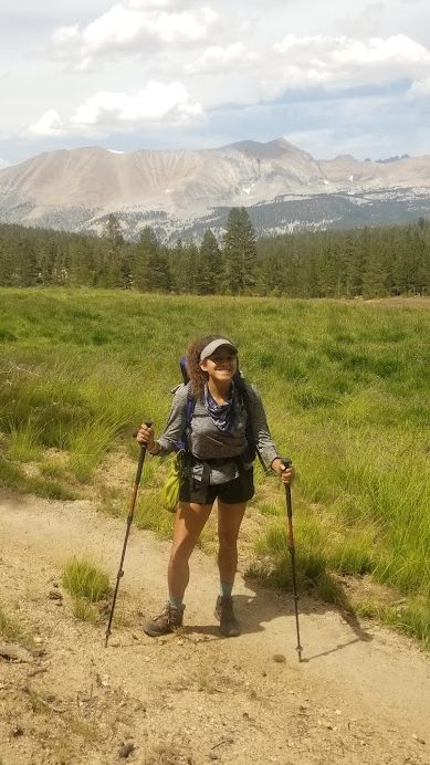
Tynesha and I had been dating since February. Her experience in the National Parks of the Sierra was largely relegated to front country visits. She knew what I did for work in the parks, but hadn’t seen it up close. I thought it would be fun if we could spend some time together in my favorite playground. Somehow, someway, I was able to convince her in a hairbrained plot to join me on a trek. She rustled up her gear, I raided the guide pantry, and we were off!
Day 0: 7/15/18 – Logistics and Coordination

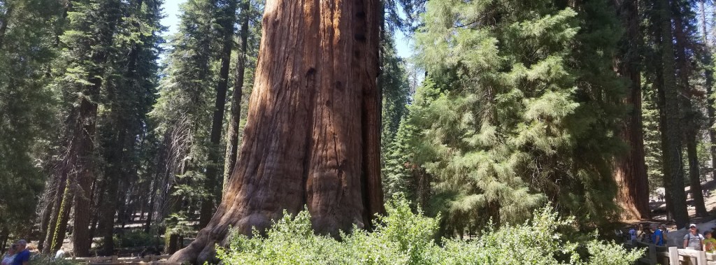
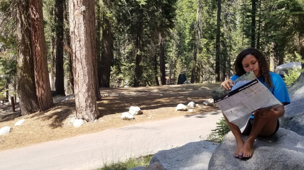
The plan was hatched: Tynesha would meet me in Mariposa, CA, where our guiding house was located. We would drive from there to Lodgepole Visitor Center and Campground in Sequoia National Park. We didn’t have a permit, so we made sure to arrive early in the day to apply for a walk-up permit. This was a risk, for sure, but we were willing to hike big miles and didn’t mind being flexible if our dream-trip wasn’t available. Luckily, we got the permit we needed. We then booked a reservation for Lodgepole campground that night, and would spend the rest of the day enjoying the Giant Forest and Crescent Meadow before going to bed.
Day 1: 7/16/18 – Crescent Meadow to Kaweah Gap (about 22 miles)

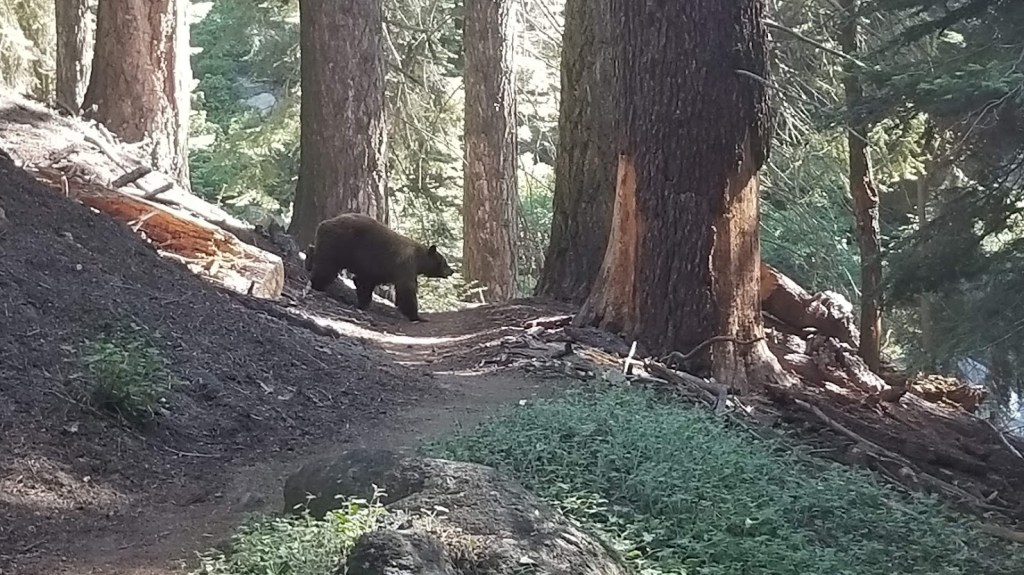
We woke up with the sun, quickly tore down camp, and hopped into Tynesha’s car to drive to the Crescent Meadow Trailhead. The western terminus of the trail is ripe with day hiking destinations – Crescent Meadow itself and Moro Rock are very popular. I remember how excited we were the first few miles. This feeling would soon be amplified when I heard Tynesha gasp from behind me – “Joe, a bear!”. Lo and behold, we were in the presence of a juicy sow bear with her two cubs! These bears were doing bear things – searching for grubs and minding their own business – so we followed suit by giving them a wide berth before moving on.
Things opened up almost immediately afterward. Views of the Great Western Divide and the middle Fork of the Kaweah River were accessible. Alpine flowers were in bloom and water trickled down the granite… it was a truly a beautiful day. We came across Bearpaw Meadow around 11 miles deep, which is a popular High Sierra Camp that offers hikers front-country like accommodations while simultaneously being located in the solitude of the wilderness.
We stopped for lunch a few miles later under a geological feature called Valhalla (also known as the Angel Wings). The headwaters of the Middle Fork of the Kaweah River sprout from underneath this outstanding geographical phenomenon, providing a view too good to pass up. We cooled off in the water and enjoyed lunch before packing up and moving onto Hamilton Lakes. The ranger who had given us our permit the day before mentioned this was usually the furthest most hikers are capable of making it on their first day out from the terminus, but at only 14 miles, we felt comfortable to continue.

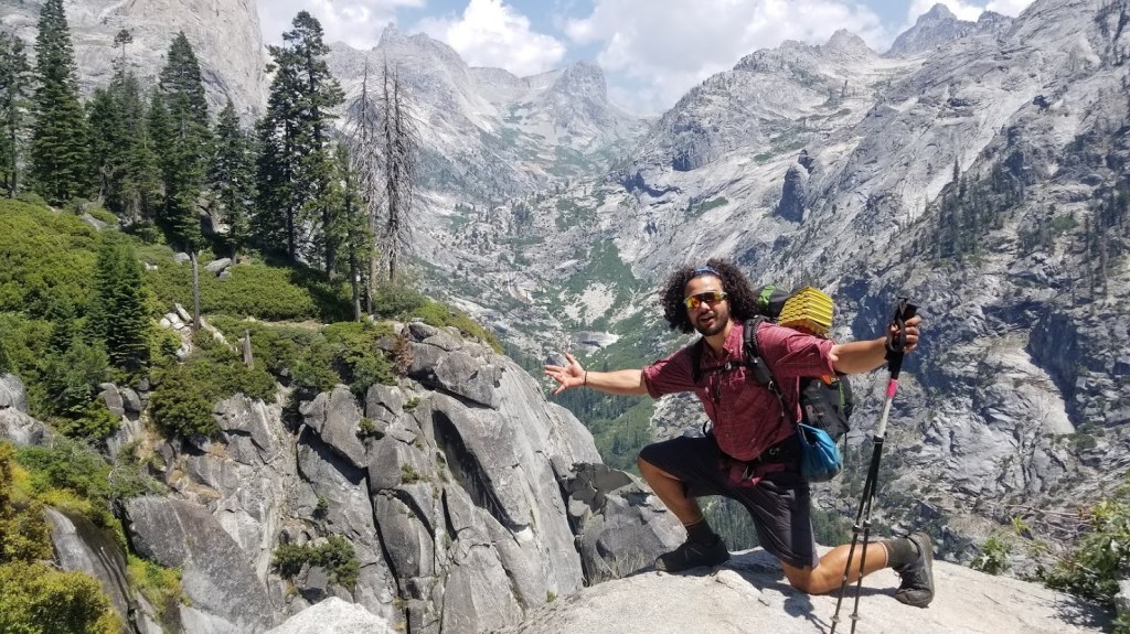
It is a good thing we enjoyed the subalpine scenery of Valhalla and Hamilton Lake, because the trail would segue immediately into a steep incline for a couple thousand feet immediately after. Now, at this point I had hiked my fair share of National Scenic Trails, but the High Sierra Trail was really blowing me away. It captured the drama of the Sierra at an incredibly good value, and at only 15 or 16 miles in, this was the first challenging climb of the hike. The trail snaked up a ridge toward Kaweah Gap, high above Hamilton Lake. There’s a unique section of trail that contains a tunnel blown through the rock years before – it felt Grand Canyon-esque. Moreover, I was stoked that I didn’t convince Tynesha to join me on a lame expedition.

The sun was close to setting by the time we arrived at the top of the climb. Kaweah Gap and the Great Western Divide lay before us in all their glory. We hopped into Precipice Lake to cool off. I’d later learn that this lake is somewhat famous for being featured in Ansel Adams’ Frozen Lake and Cliffs.
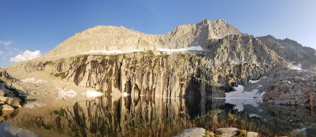
Now early evening, we decided it was time to seek camp. Tynesha’s dogs were barking and mine weren’t far off either, so we pushed over the gap and found camp right as darkness fell. The two of us enjoyed a dehydrated meal before curling up inside to avoid the mosquitos. Day 1 was a massive success, and one of my favorite all time in the state.

Day 2: 7/17/18 – Kaweah Gap to Junction Meadow (about 20 miles)

It’s easier to make miles when you have a full day on trail, and that’s exactly what we did. We were up with the sun and enjoying breakfast while we walked. It was an unremarkable morning (as far as glorious mornings in the Sierra go, anyway). Tynesha and I trekked by Sky Parlor Meadow while we hopped over the occasional blow-down. Somewhere in the thicket my eye caught an animal I’d never seen before. It looked dense and fluffy, too thick to be a marten, but not tall enough to be a coyote. Alas: the Sierra White-Tailed Jack Rabbit!

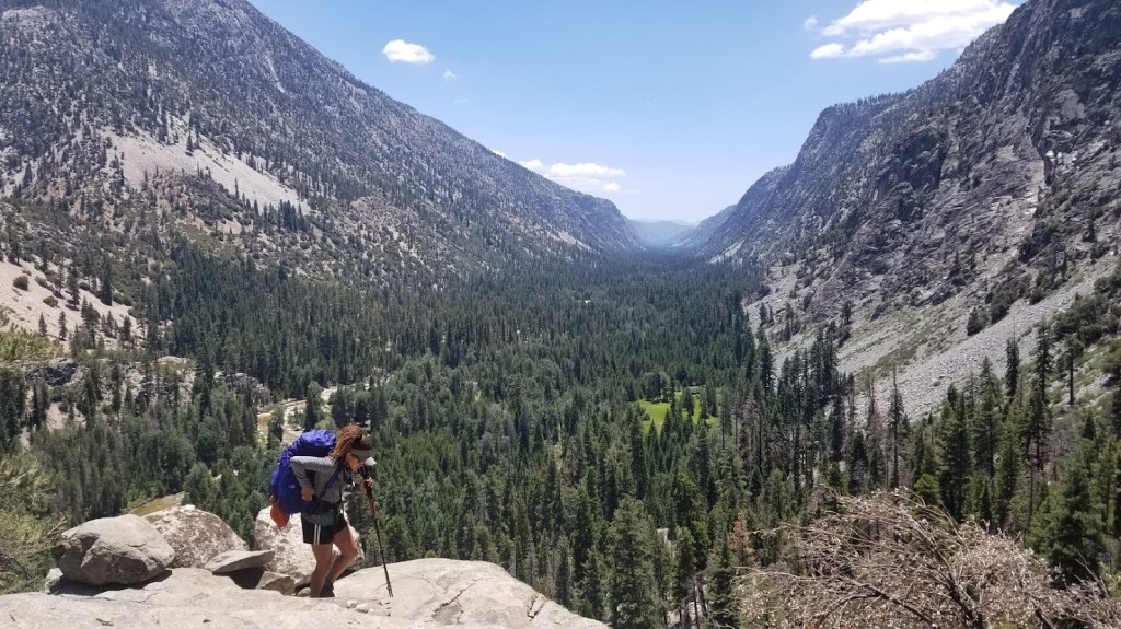
Today would be much hotter than expected. Even at elevation, temperatures seemed to stretch into the low 90s by midday. We descended the plateau we had been hiking on and began to drop into the Kern River Valley. For my money, this was one of the most beautifully displayed examples of a U-shaped glaciated valley I had ever seen.

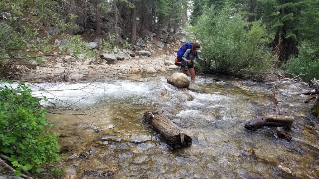
Trouble hit me in the early afternoon. Earlier in the day I had consumed some dried apricots that I had rummaged from the guide pantry… but in hindsight, I had consumed a few apricots too many. GI distressed fell on me with a vengeance. By the time we had reached the rushing cool water of the Kern River, I needed to take a moment to relieve myself in the worst way. It would be a battle I’d revisit for the rest of the afternoon, cursing every bite I had taken of that dreadful dried fruit. I finished up my first bout with the facili-trees and pushed forward to catch up with Tynesha. When I finally met up with her on the banks of the Kern River, she was fully submerged in the cool water and enjoying lunch! This area is famous for the Kern Hot Springs, but they were far too hot to enjoy on a day like this, so we settled for the relaxing gurgle of the alpine water downstream instead.
We walked the remaining hours of the afternoon to Junction Meadow, where we’d set up camp. I was hurting at this point from the various bathroom visits, much to my chagrin. Tynesha stepped-up in a big way that evening. She erected the tent, gathered water, and even helped with the fire – all with a smile on her face. The fire was a special treat, as not only did it provide some ambiance for our first long backpacking trip as a couple, but it also warded off the swarm of mosquitos who came to life in the early evening.
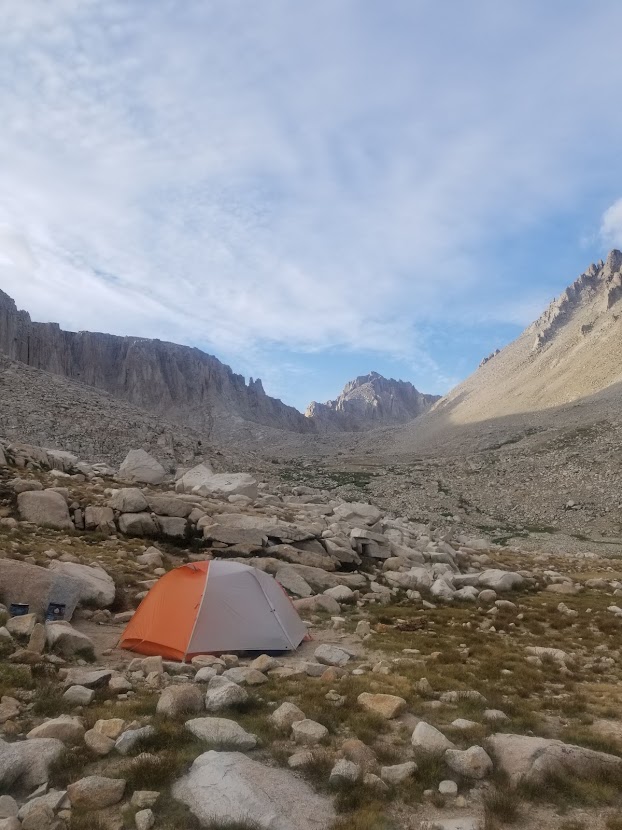
Day 3: 7/18/18 – Junction Meadow to Guitar Lake (about 14 miles)
Day 3 is where logistics really seemed to kick-in. Due to permitting and the fragile environment of the Eastern Sierra, we weren’t allowed to camp east of Mount Whitney, which was less than a day away. We decided to camp as close to the base of Whitney as possible to ensure our last day wasn’t harder than it needed to be, but this meant that today would be our shortest of the trip. No problem – we were tuckered from the back to back 20-mile days, so sleeping-in felt like a real treat.

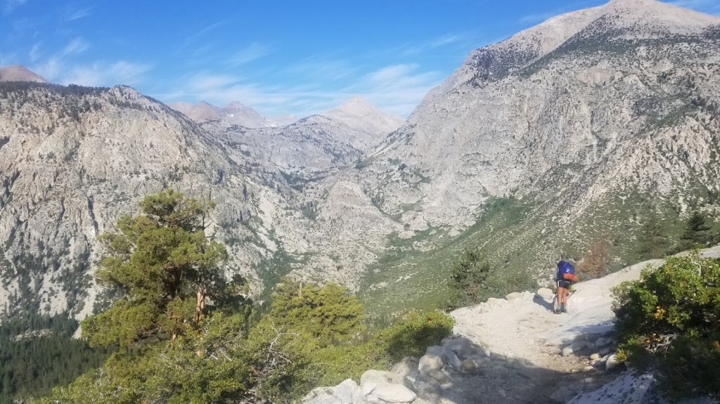
The sun was up by the time we left camp. It was another toasty day, but fortunately we were now gaining elevation drastically, which meant cooler temps in general. We reached the junction of the John Muir Trail/Pacific Crest Trail after a few hours of sunny hiking with good views. I couldn’t help but reminisce with delight on my previous experience on this stretch of trail, which you can read about here. It was a relatively easy climb, especially since we took our time to hike slowly and enjoy the vistas provided by the mountains.

We arrived at Crabtree Meadow around lunch time. This is one of the primary campgrounds for hikers on the JMT/PCT who want to summit Mt. Whitney. It has a ranger station and a pit toilet (open air, which is a fun experience). Here we snacked on lunch, and eventually, I drifted off to sleep for an afternoon cat nap. Tynesha woke me up some time later and we walked the remaining two hours eastward and into my favorite ecosystem of the mountain range: the alpine zone.

Afternoon brought a few hours of overcast weather. We reached the infamous Guitar Lake, our destination for the night, before too long. The area is delicate and tent spaces are sparse, so we picked a flat, secluded section with ample views of both the lake as well as the Sierra Massif. Tynesha and I set-up our tent, and after some convincing, we both took a quick dip in the lake, which sits at around 11,500 ft. It is the chilliest, highest elevation lake I’ve had the privilege of splashing around in to this day. The two of us enjoyed an early dinner before hitting bed while the sun was still up. After all, we’d have an early wake-up the following morning: Mount Whitney awaited.

Day 4: 7/18/18 – Guitar Lake to Whitney Portal (about 16 miles)
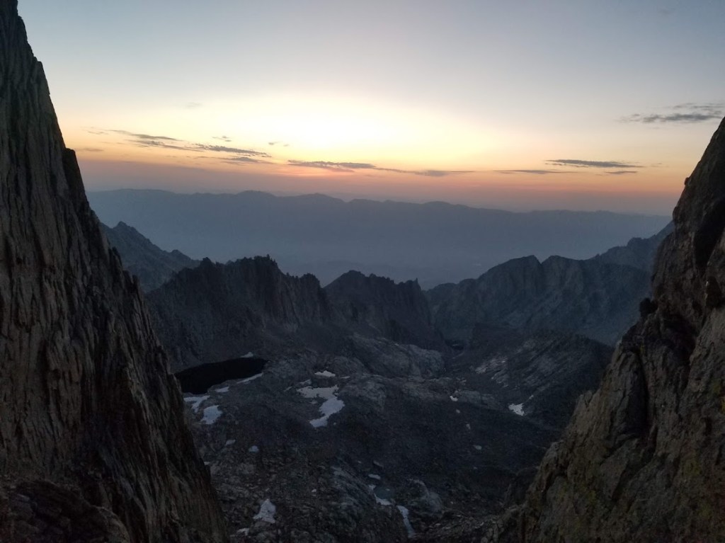
Day 4 started hours before sunrise. We tore down our tent, used the bathroom (our first respective wag-bag usage, nice!), and followed the twinkle of other hikers’ headlamps in the dark. We were spurred by the excitement of summit fever and soon we were upon the crest of the Eastern Sierra. We treaded the precipitous side trail to the summit with care, anxious to avoid a tumble in the dark to an untimely demise.

We summitted the tallest mountain in the continental United States with the rising of the sun. It was the most crowded section of the entire trail up until that point. We bumped shoulders with High Sierra Trail hikers, JMT hikers, PCT hikers, and day hikers alike. This is the pinnacle of many recreational enthusiasts’ hiking careers, and thus, much outdoor decorum goes out the window on the summit. Cairns are erected, loud phone calls are made, and drugs are consumed, all seemingly from the top of the world (or at least of California).

It was a special moment for Tynesha and I that I look back at fondly. On one hand I felt I was sharing with her something that was important to me… but the truth is, her presence there made it all the more special for my own experience. The summit was an event that demanded its own attention, so we took our time enjoying the views and soaking in the mountain air at 14,505 ft. before beginning our long descent towards the east-side.


The remaining miles brought us out of the National Park and into the barren, rocky landscape of Inyo National Forest. Mount Whitney’s eastern ascent is an incredibly popular hike for those who have permits and the gumption and training to pursue it, so naturally we battled hoards of day hikers as we lengthened our trekking poles and plodded toward the end of trail. By this point we were tuckered and dehydrated from the early morning hiking. Our energy waned among the sunbaked rocks. Before long we were both eager to make it to Whitney Portal, cursing every steep step we took with our aching feet.

Two weary hikers arrived at Whitney Portal just after lunch on day 4. We disposed of our used wag-bags in the specially-designed waste vestibules at the portal before visiting the general store. Another hiker frantically cried out while we enjoyed Gatorade and ice-cream: while we were shopping, she’d left her backpack outside on a picnic table, which was quickly snatched by a bear! It was a fitting end to an epic adventure… but was the adventure actually over, or just beginning?
Back to Crescent Meadow: About 277 miles hitched, 157 driven
Our trip was well-planned up until this point. We didn’t have a way back to our vehicles on the west side of the Pacific Crest, so we’d either need to catch a bus, or hitch-hike. Hitch-hiking seemed like the best option to save money and travel quickly, so that’s what we did… but it wasn’t exactly a walk in the park:
- Whitney Portal to Lone Pine – about 11 miles.
- It took us maybe 30 minutes before we were picked-up by a mother and her two kids in their minivan. They were British tourists on summer holiday in the US. They were heading southbound from Lone Pine, so we said goodbye to them there. It was a nice ride, 10/10.
- Lone Pine to Bishop – about 60 miles
- We splurged for Mexican food in the infamous climbing community of Lone Pine, CA, before sticking our thumbs out. It took probably 90 minutes in the sun before a pick-up finally pulled-over. We enjoyed the hour-long ride with a solo hiker and his retriever who were eager to spend a night fishing in the mountains. He was a reasonable, quiet dude who was easy to get along with, plus his dog was cute. He was heading back west into the Sierra, so he dropped us off in Bishop. 8/10 because I felt I had to carry on conversation.
- Bishop to Lee Vining – about 65 miles
- Bishop was much trickier. We were dropped off in a bad area for hitching, plus the sun was setting soon, so we walked along a sketchy and busy road until we could reach an area with an appropriate pull-out. Even then, it took close to two hours before we finally got a ride (I think my appearance scared people away, but luckily Tynesha is cute). The guy who picked us up demanded we leave all our possessions in the bed of his truck. It turns out he was in the military, had served multiple tours in Afghanistan, and was on his way to visit his kid (who lived with his mother, whom our driver had separated from). Honestly, this was by far the sketchiest drive of my life. We felt we were in the presence of not-too-far-off danger the entire ride. The man spent a majority of the journey explaining how many communities he had bombed in the Middle East, and almost worse, how he wasn’t at fault for any of it. The guy was clearly battling some demons, and it was in our best interest to keep our mouths shut as much as possible. We were thankful to be dropped off in Lee Vining as he continued north. 2/10 hitch for fear for our lives.
- Lee Vining to Tuolumne Meadows – 21 miles
- Lee Vining is home to the Woah Nellie Deli at The Mobil. It’s basically a gas station that offers ridiculous food with relativity to its geographic proximity (margaritas, fish tacos, bison ribs, etc.) and sometimes has live music. We feasted on dinner like the hiker trash royalty we were before cleaning our plates and heading back to the road. Now we were only a half hour from Yosemite National Park, where hitch hiking is common, so it only took us a few minutes before we got a ride, despite the fresh nightfall. Our generous driver was an employee for the park concessionaire who worked in Yosemite every season. 10/10 ride because the dude knew all hitch-hiking protocol.
- Tuolumne Meadows to Yosemite Valley – 50 miles
- We were lucky to know some good people who had campground reservations at Tuolumne Meadows that night, so we hunkered down with them with all the amenities of the legendary campground at our disposal. The next morning we said goodbye to our friends, grabbed breakfast at the Tuolumne Meadows Grill, and enjoyed the glory of the alpine meadow while warming in the sun. Tynesha roped us a ride within 20 minutes of hitching. It was a traveling couple who were in the park for the first time. I gave them some light interp while Tynesha chatted them up about traveling through Italy. Yosemite Valley was socked-in with disgusting wildfire smoke, so views were paltry. They dropped us off at Bridalveil Fall in favor of pushing further into the valley. 9/10 hitch.
- Yosemite Valley to Mariposa – 70 miles
- Smoke is gross, and the morning was hot. It only took us about 10 minutes to get a hitch in the valley. Our benefactor was a driver for the Yosemite shuttle service who was on a day off and needed to go to Merced to visit her mom. The only problem was her car didn’t have back seats… instead, we needed to sit in the bed of her Tacoma with its shell on. We crammed in the back with the junk she was carrying and held on for dear life. It was incredibly hot back there, and even worse, I began to get carsick. In Oakhurst we stopped to get gas and the driver asked us to hop out to get some fresh air. She was familiar with the area, obviously, and was kind enough to take us to the front porch of the guide house. It was a long, brutal hitch, but we finally made it back to my car! It took us almost exactly 24 hours from Whitney Portal to reach this point. 6/10 hitch – even though it was sketchy and uncomfortable, it was incredibly clutch.
- Mariposa to Crescent Meadow – 157 miles
- Ok so this isn’t technically a hitch, but I’m including it anyway. We spent the entire rest of the day at the guide house. I enjoyed showing Tynesha our living accommodation, the guide gear, and all other aspects of how I spent my dirtbag days. We made burritos, drank some tequila, and hung out with one of the other guides before going to bed. The following day we took my VW Golf and drove back to Crescent Meadow to pick-up her car. After a quick bite in Fresno we said our goodbyes.

Closing Thoughts
The HST is probably the best value hike I’ve ever done. Every mile has incredible scenery. Permits are tough, but if you’re willing to hike larger days, are obtainable. The biggest struggle is car logistics… but if you’re willing to hitch-hike, can make for its own adventure. In short, I highly recommend it.
